
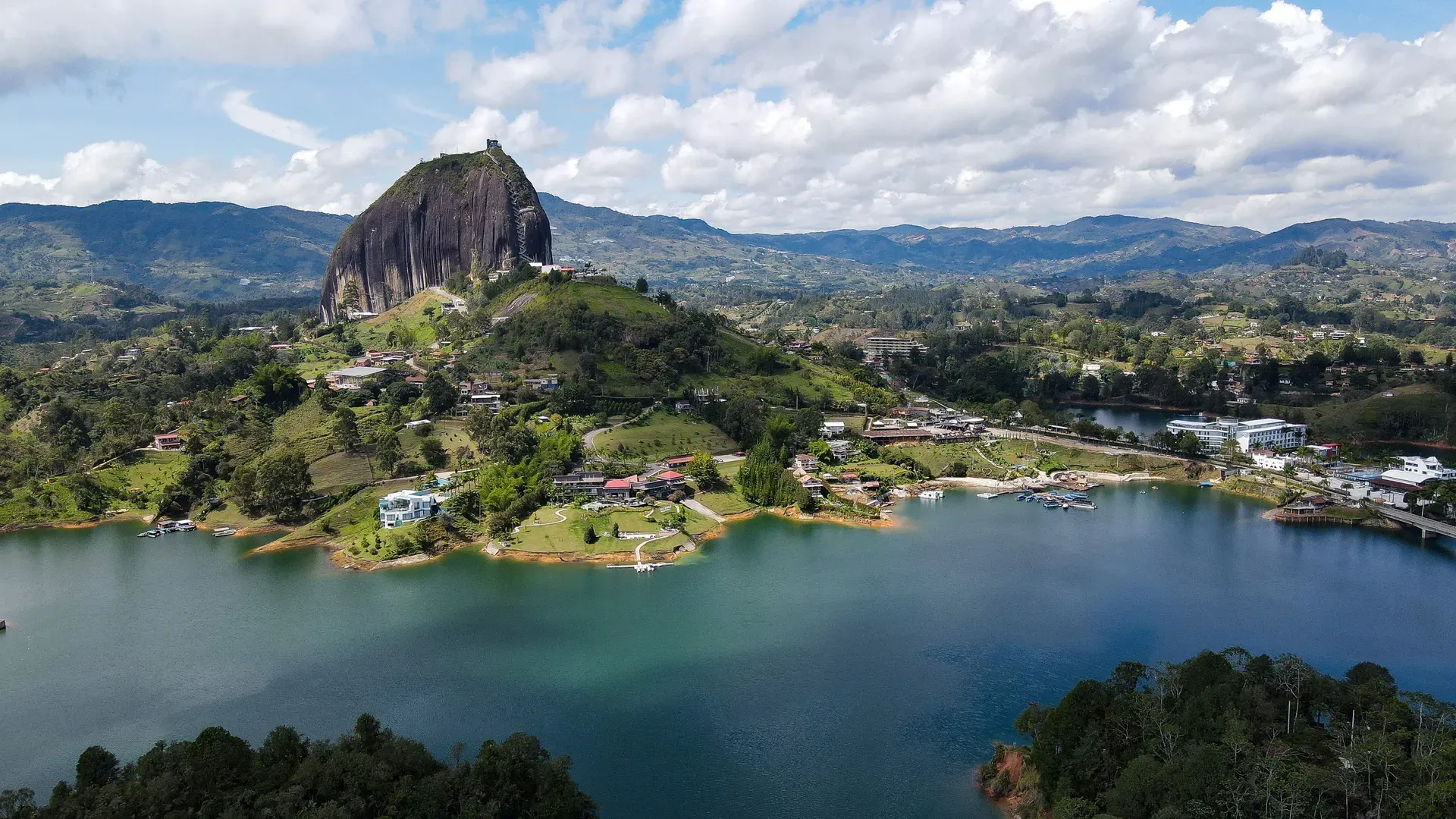
Two hundred and twenty meters of solid granite rise above a 2,262-hectare artificial reservoir in Antioquia, Colombia. Visitors climb 740 concrete steps built into a natural fissure to reach the 2,135-meter summit.
Two hundred and twenty meters of solid granite rise abruptly from the rolling hills of eastern Antioquia. La Piedra del Peñol extends another 1,000 meters below the surface. A zigzagging staircase of 740 concrete steps fills a massive vertical crack on the rock's northern face. Climbers who make the 20-minute ascent reach a summit elevation of 2,135 meters. From the top viewing tower, the landscape breaks into a maze of green peninsulas and deep blue water. This is the El Peñol-Guatapé reservoir, a 2,262-hectare artificial lake created in the 1970s to generate hydroelectric power.
The site sits exactly on the border of two municipalities, El Peñol and Guatapé. This geographic reality fuels an ongoing territorial dispute. Both towns claim the monolith as their own. Guatapé even attempted to paint its name in giant white letters on the rock face in 1987, managing only a 'G' and part of a 'U' before authorities intervened. Today, those giant white letters remain visible from miles away. The rock draws thousands of visitors daily, transforming a quiet agricultural zone into a massive commercial hub.
Buses depart every 30 minutes from the Terminal de Transporte del Norte in Medellín. The 80-kilometer drive takes two hours and drops passengers directly at the pedestrian entrance. From there, visitors either walk the steep incline to the base or hire a motorized tuk-tuk for COP 12,000. Crowds flood the narrow staircases by 10:00 AM daily. Tour buses drop hundreds of visitors at the base, turning the steep ascent into a slow, congested march. Heavy rain makes the concrete steps slick. Visitors should arrive right at the 8:00 AM opening time on a Tuesday or Wednesday to avoid the gridlock. Bring Colombian Pesos, as the ticket booths reject credit cards and foreign currency. The single ATM in the nearby town of Guatapé frequently runs out of cash.
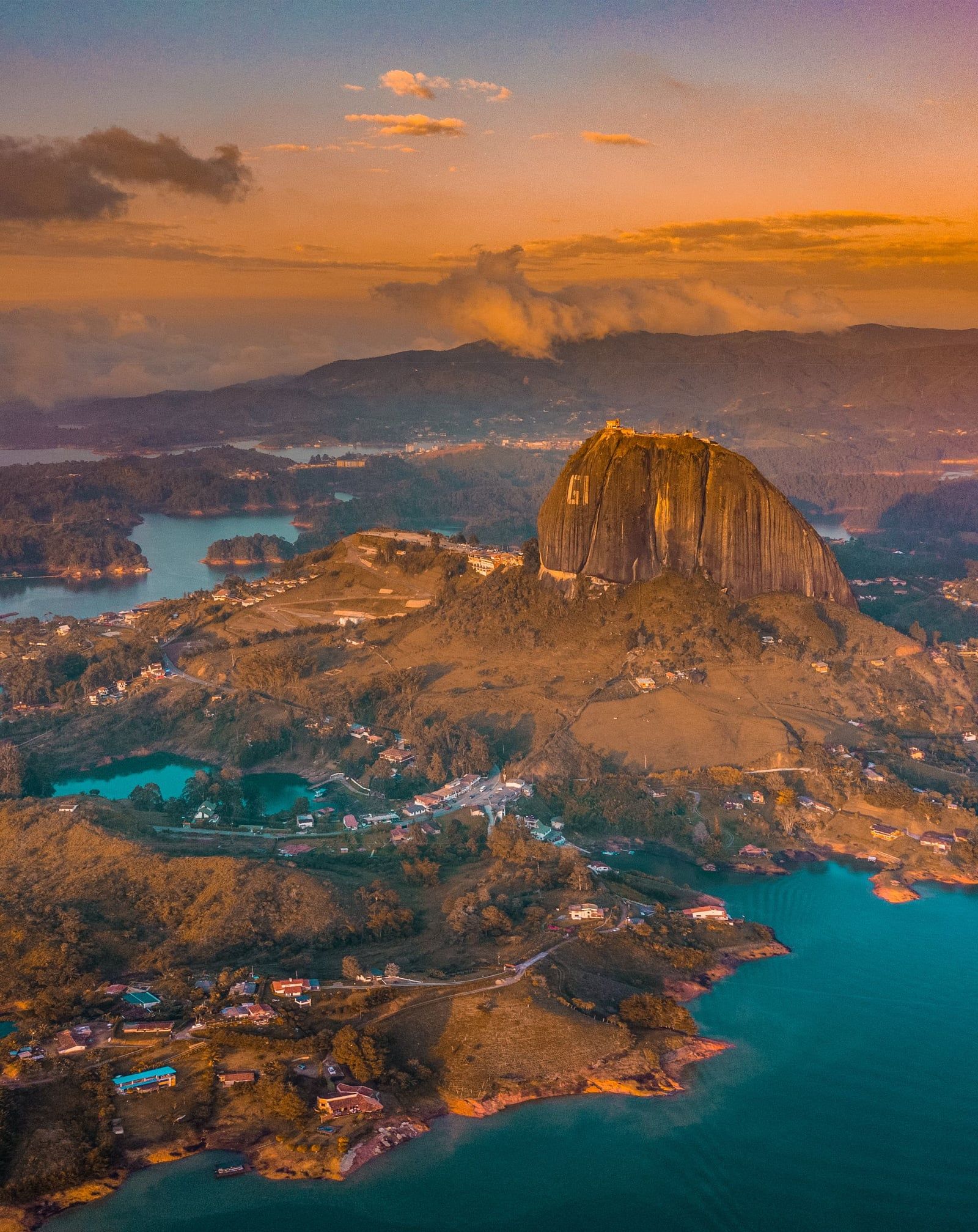
The monolith formed between 65 million and 80 million years ago deep within the Earth's crust. It belongs to the Antioquia Batholith, a massive 7,800-square-kilometer body of intrusive igneous rock. Tectonic plate movements pushed this granite mass upward over millennia. Surrounding softer rock eroded away, leaving only the weather-resistant granite tower exposed above the soil. The rock survived millions of years of wind and water erosion due to its dense mineral composition. Geologists classify the formation as an inselberg, an isolated rock hill that rises abruptly from a gently sloping plain.
Luis Eduardo Villegas López, Pedro Nel Ramírez, and Ramón Díaz completed the first documented climb on July 16, 1954. The trio spent five days scaling the sheer vertical face. They wedged wooden sticks into the rock's single major fissure, creating a makeshift ladder system to reach the summit. Local farmers considered the massive rock a nuisance because it occupied land useless for agriculture. Villegas purchased the monolith from these farmers shortly after his successful climb. He constructed the first permanent wooden staircases and opened the site to paying visitors. The Colombian government officially declared the monolith a National Monument in the 1940s, recognizing its unique geological status even before the first ascent.
The landscape surrounding the rock changed drastically in the 1970s. The Colombian government flooded the region to create the El Peñol-Guatapé reservoir, submerging the original town of El Peñol under millions of gallons of water. The monolith suddenly stood above a sprawling network of islands rather than rolling farmland. Residents of the flooded town relocated to a newly built municipality, while a theme park called Réplica del Viejo Peñol now recreates the lost village streets nearby.
Villegas's family eventually replaced the decaying wooden stairs with a permanent 740-step concrete structure. Today, the family still owns and operates the site. Medical personnel staff two priority attention points along the ascent to treat climbers suffering from altitude sickness or dehydration. The site handles thousands of climbers daily, requiring constant maintenance of the concrete steps and metal handrails.
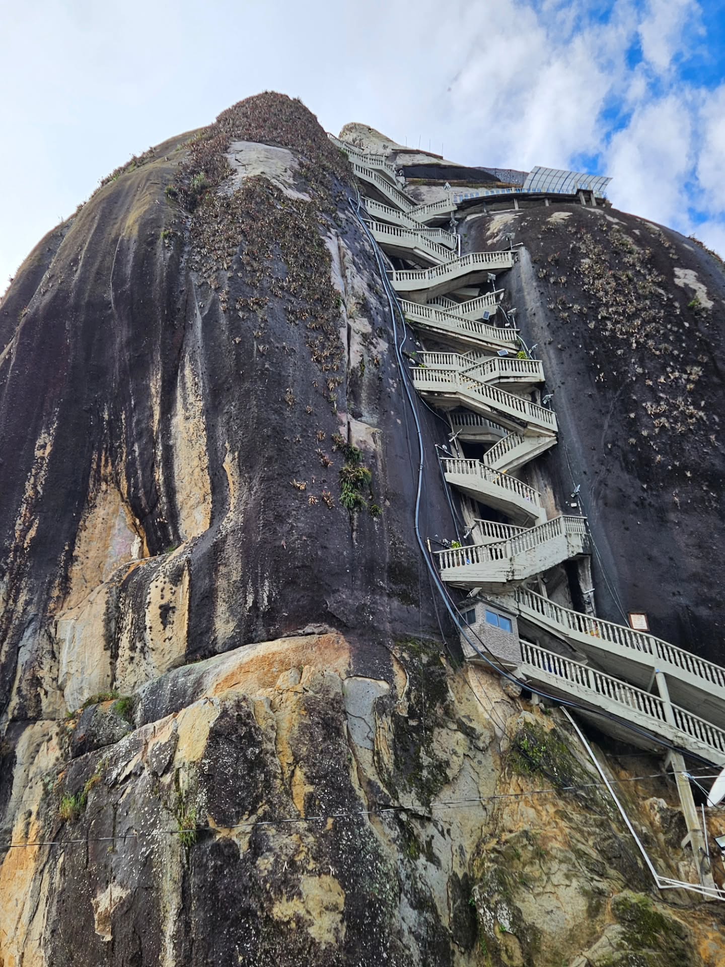
The monolith measures 285 meters in length and 110 meters in width at its base. It consists entirely of granite, quartz, and feldspar. The rock's surface is smooth and nearly vertical on three sides, with a single prominent fissure running up the northern face. This crack houses the 740-step concrete staircase. Builders anchored the steps directly into the stone walls, creating a zigzagging path that requires climbers to navigate tight switchbacks. The steps feature painted numbers every 25 intervals, allowing climbers to track their exact progress.
The summit sits at 2,135 meters above sea level. Visitors who reach the top find a three-story brick viewing tower built onto the uneven granite surface. The observation deck provides an unobstructed 360-degree line of sight over the 2,262-hectare reservoir. Green peninsulas weave through deep blue water, marking the peaks of hills that existed before the 1970s flooding. Speedboats and jet skis cut white wakes across the lake below. The temperature at the top averages 18 °C, though the complete lack of shade exposes climbers to intense equatorial ultraviolet radiation.
A small shrine dedicated to the Virgin Mary sits at the halfway point of the ascent. This alcove provides the only flat resting area on the staircase. Climbers use this spot to catch their breath and let faster groups pass. The descent requires navigating a separate, narrower set of stairs that funnels visitors down the opposite side of the fissure. This one-way system prevents collisions between ascending and descending crowds. The concrete path becomes highly slippery during sudden afternoon rain showers, requiring a firm grip on the metal handrails. The base of the rock features a massive paved parking lot charging COP 6,000 per hour, a row of ticket booths, and colorful murals detailing the site's indigenous history.
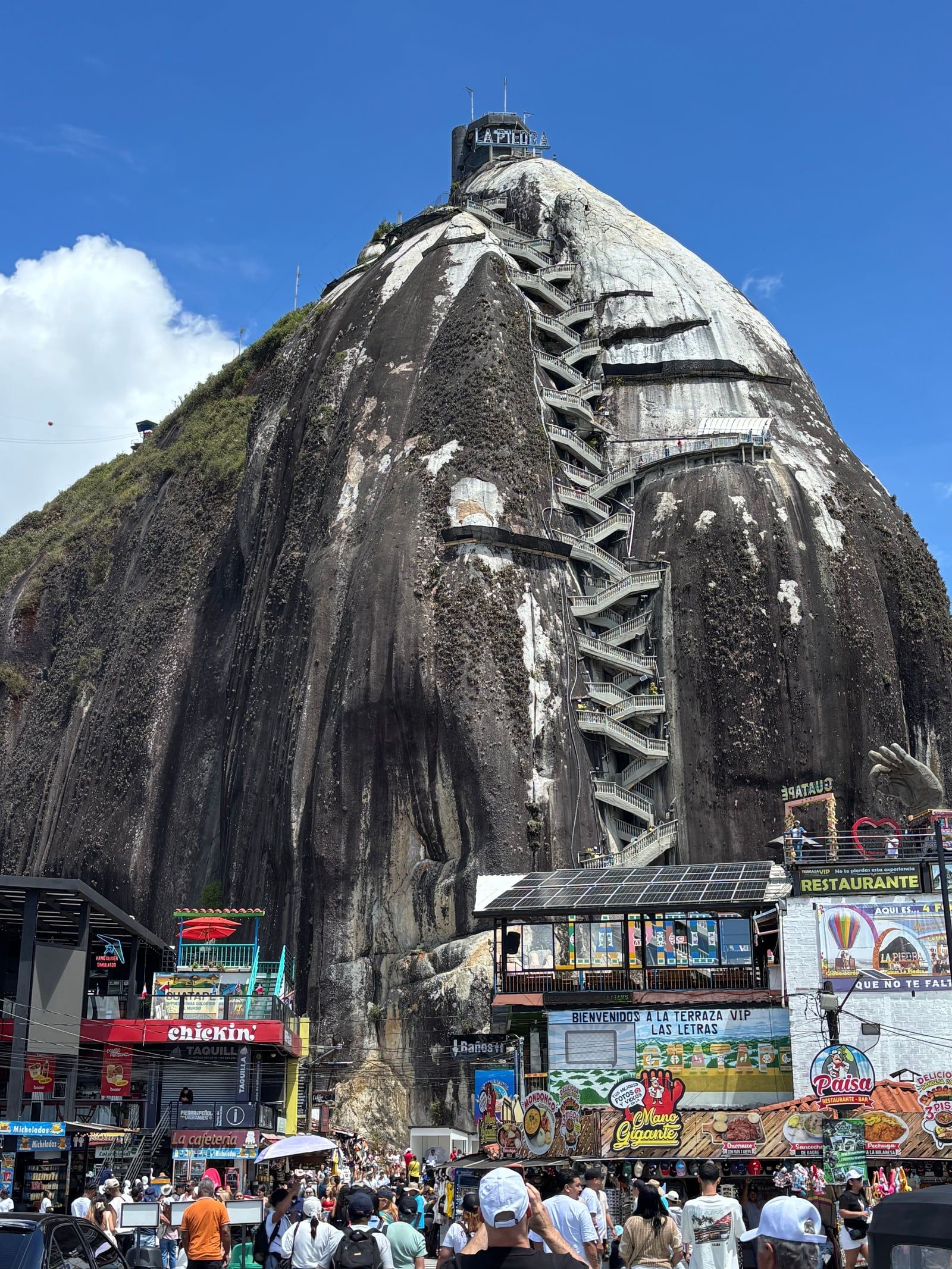
The ancient indigenous Tahamí people worshipped the monolith long before European colonization. They called the rock "mojarrá" or "mujará," which translates directly to "stone." The Tahamí believed the massive granite tower possessed a distinct spiritual energy and used the site for religious ceremonies. Colorful murals at the base of the rock currently depict these early indigenous traditions, documenting the region's pre-colonial history. The rock acted as a natural navigation point for tribes moving through the dense Antioquian forests.
The rock functions as a physical boundary and a source of intense local pride. The municipalities of El Peñol and Guatapé both claim ownership of the landmark. This rivalry peaked in 1987 when Guatapé residents attempted to brand the rock with their town's name. The unfinished white letters "GI" stand 30 meters tall on the northern face. The graffiti remains a permanent fixture of the landscape. The government halted the painting project, ruling that neither town could deface a National Monument.
Local vendors rely entirely on the daily influx of climbers. Commercial stalls ring the base and the summit, selling mango paletas, cold water, and artisan crafts. The rock transformed a quiet agricultural zone into an economic engine. Visitors must pay the COP 20,000 entrance fee in cash, directly funding the local families who maintain the stairs and operate the medical stations. The site employs dozens of local residents as parking attendants, security guards, and maintenance workers. Children are permitted to climb, but the physical exertion requires parents to pace the ascent carefully.
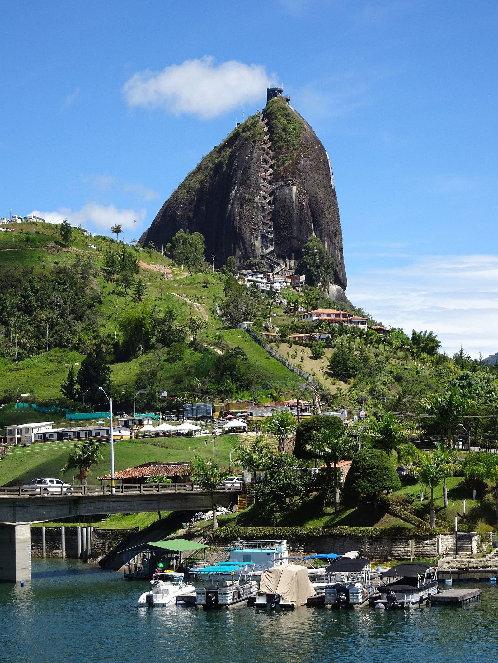
The monolith extends approximately 1,000 meters below the Earth's surface, meaning visitors only see a fraction of the rock.
The first climbers took five days to reach the top in 1954, using wooden sticks wedged into a natural crack.
The giant white letters 'GI' on the rock are the remnants of an aborted 1987 attempt to paint the word 'GUATAPÉ'.
The surrounding 2,262-hectare lake is entirely man-made, created in the 1970s to generate hydroelectric power for the region.
A small shrine dedicated to the Virgin Mary sits halfway up the 740-step staircase, providing the only flat resting area.
Luis Eduardo Villegas purchased the rock from local farmers who considered the massive stone useless for growing crops.
Animals are strictly banned from the stairs to prevent accidents, with exceptions made only for medically prescribed service dogs.
Climbers must ascend 740 concrete steps to reach the highest viewing tower. The main rock advertises 640 steps, but an additional 100 steps lead to the final observation deck.
The standard entrance fee is COP 20,000 to COP 25,000 per person. The ticket booth only accepts cash in Colombian Pesos, though skip-the-line tickets cost COP 59,000 online.
The ascent takes 15 to 30 minutes depending on your physical fitness. A complete visit requires 1 to 3 hours to allow time for resting and viewing the reservoir.
Geologists estimate the granite monolith is between 65 million and 80 million years old. It formed deep underground as part of the Antioquia Batholith before erosion exposed it.
No elevators or cable cars exist at the site. The summit is only accessible by climbing the 740-step staircase, making it entirely unsuitable for wheelchair users.
The letters 'G' and part of a 'U' are remnants of a 1987 property dispute. Guatapé officials tried to paint their town's name on the rock but were stopped by national authorities.
Pets are strictly banned from the staircase. Only certified service dogs with a supporting medical prescription can accompany visitors on the climb.
The site opens daily at 8:00 AM and closes at 6:00 PM. Arriving right at 8:00 AM helps you avoid the severe crowding that begins around 10:00 AM.
Two medical assistance points staffed by paramedics operate along the staircase. They handle cases of exhaustion, dehydration, and altitude sickness for climbers.
Buses depart every 30 minutes from the Terminal del Norte in Medellín. The 80-kilometer ride takes about two hours and drops passengers directly at the rock's pedestrian entrance.
Browse verified tours with free cancellation and instant confirmation.
Find Tours